
Guest Blog: Calgary Atlas Project
Written by Noreen Humble
Acting Director (2020-21), Calgary Institute for the Humanities

The Calgary Atlas Project seeks to document forgotten and lesser-known stories from Calgary's history by mapping them onto the city's geography and highlighting significant sites, events and people in Calgary's past. From the start it has resolutely set out to be a collaborative project, aiming to work as far as possible with local writers and artists from the communities and histories being explored and to use local archives and resources. Important to the project too is not just documenting these histories in innovative ways but also disseminating them as widely as possible among the city's communities in order that we all be enriched by our increased understanding of the past and its reverberations in the present.
The project is an initiative of the Calgary Institute for the Humanities (CIH). Established at the University of Calgary in 1977, the CIH is Canada's oldest humanities institute. It was founded to support the study of the human experience, beyond what the social and natural sciences provide, and it has long been a pioneer in the area of community-engaged research. Spearheaded by the CIH's Director, Jim Ellis, the Atlas Project was born in 2014 and steered by a group of five University of Calgary professors with specialties in film, literature, architecture, geography and history.

The pilot map, A Queer Map: Gay and Lesbian Calgary, documents Calgary's rich LGBTQ2S+ history, drawing on the historical research of the Calgary Gay History Project with research by Kevin Allen and artwork by Mark Clintberg. Its exploration of the places and faces of Calgary's LGBTQ+ history beautifully documents the scenes and bars where these communities thrived as well as the people and organisations whose activism and initiatives raised much needed awareness and support. The map reveals the strong sense of resistance, collaboration and pride of these communities in the face of an often inhospitable city over the years.
You can read about A Queer Map in Sprawl's most read article of 2020 at https://www.sprawlalberta.com/the-forgotten-calgary-map.

The second map, First Nations Stampede Map: A Guide to First Nations History at the Calgary Stampede, likewise documents resistance, collaboration and pride but among a different community. Adrian Stimson, an artist from the Siksika Nation, mapped stories of First Nations sometimes controversial participation in the Stampede since its inauguration in 1912.

Photo: Adrian Stimson, an artist from the Siksika Nation, mapped stories of First Nations history at the Calgary Stampede onto a buffalo robe.
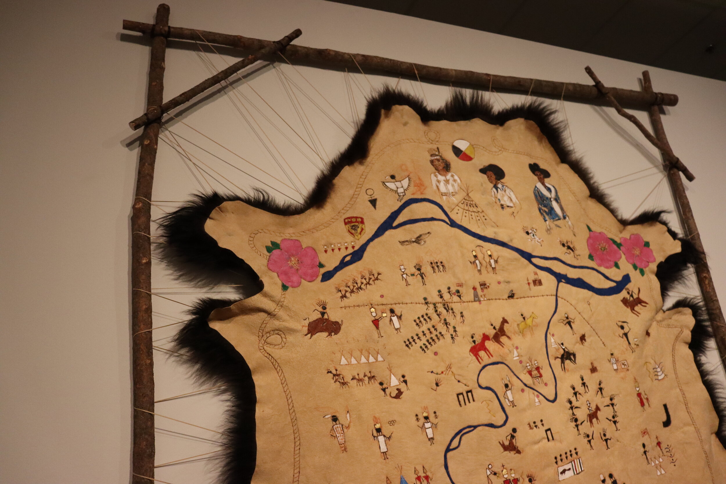
Photo: Adrian Stimson, an artist from the Siksika Nation, mapped stories of First Nations history at the Calgary Stampede onto a buffalo robe.
Stimson uses Indigenous ways of knowing in order to decolonise and reclaim this history even as such practices seek to remember and inform. His rendering of these stories using pictographs in spiral and linear arrangements painted onto a buffalo robe plays with time and space, reflecting and reversing the way colonial stories have overlaid Indigenous histories and territory. It is both celebratory and educational. The stunning original artwork is currently on display at the Glenbow Museum. You can watch the virtual launch of the First Nations Stampede Map and Adrian Stimson's artist's talk at https://arts.ucalgary.ca/calgary-institute-humanities/events-and-community/calgary-atlas-project/first-nations-stampede-guide.
A third map will be available by the end of June: Calgary's Art Underground, Place, Time, Art: A Guide, which tells the story of alternative and underground artists and art movements in the city.

Artwork for this map has been produced by local collaborative art trio Drunken Paw and the research was carried out by local independent curator, Diana Sherlock. The map explores many, but by no means all, of the art initiatives that have shaped and continue to shape the local art scene.
It will be followed in quick succession by Workers Stand Up: A Calgary Labour History Map. Local artist Karen Jeane Mills has collaborated with historian Kirk Niergarth on this map, which documents sites of labour activism and radicalism, charting confrontations and spaces as well as the people and organisations whose activism has left a mark over the years on the working life of the inhabitants of this city.
In progress are three other maps: (1) Calgary's 40 Most Important Works of Architecture, (2) Calgary Screens Map, exploring the role Calgary's picture palaces and film organizations had in shaping urban character and space, (3) Food Immigration Pathways Map, detailing traces left by immigrant communities as reflected in the independently owned ethnic restaurants and groceries of Forest Lawn/International Avenue.
The project has gained much momentum in the past year thanks to the receipt of a Community Grant from the Calgary Foundation. This enabled the hiring of a Project Manager, Drew Thomas, one of whose main goals is to increase knowledge of the project among the city's diverse communities. Growing awareness of the project we hope will lead to new ideas and suggestions for further collaborations.
These projects map out important and overlooked histories of our city, many of which are simply unknown to the great numbers who have chosen to make Calgary their home since the latter part of the 20th century. While these histories live on in the memories of some, the tangible evidence is increasingly scarce, particularly with the loss of the older built environment. The project celebrates the fact that our city is both one community and many, and shows how our diversity has created and will continue to create a rich shared history.
You can find more details about the project in general at https://arts.ucalgary.ca/calgary-institute-humanities/events-and-community/calgary-atlas-project. As time goes on we will be added more details and background about the people, places and events depicted on the maps to enrich further our understanding and knowledge of these forgotten or marginalized histories.
Our maps can be purchased at the following local bookstores: Shelf Life Books, The Next Page, Pages Kensington, Aquila Books and Owl's Nest Books, as well as at Lougheed House and Maptown.
We are always happy to share the maps with any interested schools, community organisations and non-profit groups. So please reach out to us at cih@ucalgary.ca with any questions or for further information.