
Historian in Residence: The Mystery of the Big Rock
C.W. Gross is the 2021 Historian in Residence
South of Calgary, near the town of Okotoks, lies the “Big Rock.” It is a boulder weighing 16,500 metric tonnes (18,200 tons), 9 m (30 ft) high, broken into two large pieces in the middle, sitting alone in a field. The Big Rock resembles nothing around it, except for a few scattered smaller boulders of the same type. There is no layer of rock from which it could have eroded or cliff it could have fallen from. The Big Rock obviously came from somewhere else, but where it came from was a mystery.
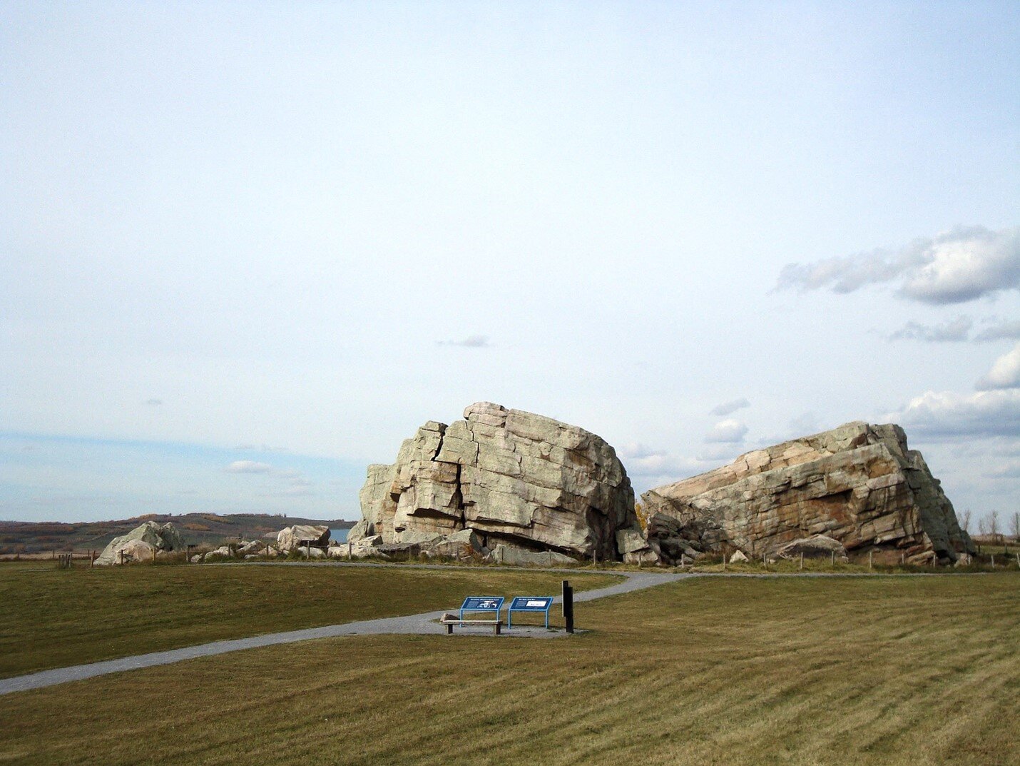
The Big Rock. Photo: C.W. Gross
This massive rock sat in its field for as long as human beings have lived in Alberta. The Niitsitapii (Blackfoot) people saw that it did not belong and told a legend of how it came to be where it rests today.
Napi is the supernatural trickster figure of traditional Niitsitapii culture. His stories are veiled lessons for many things, from Niitsitapii people’s place in the world to how not to behave towards others. The story connected to the Big Rock is the latter type.
On a hot summer day, Napi was walking along and came to rest in the shade of a very large boulder. After dozing for a while, he got up and thanked the rock by making a gift of his buffalo robe. Napi then continued on his way, but soon the weather turned and he became quite chilled. Wishing he had his buffalo robe again, he returned to the rock and asked for it back. The rock refused.
Napi got mad and, thinking that the rock could pose no threat to him, took the robe anyways. But the rock was not powerless, and started to roll after him. The two rushed across the country side, Napi running in the lead, the rock in hot pursuit.
As he ran, Napi begged for help from his animal friends. The buffalo, the deer, the elk, and the antelope all tried to stop the rolling rock, but it was so massive that they only succeeded in knocking off pieces of it. The rock itself kept rolling.
Eventually, the only animals left to help were the bats circling overhead. They dived at the rock and hit it straight in the middle, splitting it in two. The Big Rock stopped in its tracks and has remained there ever since.
For the Niitsitapii, this was an important story to teach people how to be generous towards one another and not to reclaim gifts they had given, as well as telling how bats got smushed-in noses. The name “ohkotok” is the Niitsitapii word for “big rock.”
Having recognized that the Big Rock does not belong where it rests today, the Niitsitapii sought a source. In the version of the story told by the Kainai tribe of the Niitsitapii, Napi first encountered the Big Rock in the area of Lake Francis, near the town of Valier, Montana. This was a deft observation, since this location is not far from the southernmost tip of the Canadian Rocky Mountains in Montana’s Glacier National Park, which has rocks similar to the Big Rock.
The Kainai may have arrived at an answer to where it came from by simply tracing pieces of the Big Rock south to where they could not find any more. There is, in fact, a string of boulders like the Big Rock that extend for 930 km (580 mi) in a line from the Athabasca River in central Alberta to south of the United States border.
Some of these ohkotoks are quite well known, like ones near the village of Glenwood, near Stavely, in the vicinity of Willow Creek in the Porcupine Hills, and just south of Fort Macleod. Calgary and the surrounding area is replete with examples: “Split Rock” in Confluence Park, “Buffalo Rubbing Stone” in Panorama Hills, near the access to the Inglewood Golf Course, Paskapoo Slopes near Canada Olympic Park, above Bow Valley Ranch in Fish Creek Provincial Park, several strewn across Nose Hill Park, and preserved in playgrounds and green spaces in the communities of Bridlewood, Tuscany, Valley Ridge, Sienna Hills, and Parkland. The occasional homeowner has found their attempts to build a garage frustrated by the discovery of a buried ohkotok. Several of these, including the Big Rock and a grouping in Airdrie, are now designated Provincial Historic Sites.

The Airdrie big rock. Photo: C.W. Gross.

The Split Rock at Confluence Park, Calgary. Photo: C.W. Gross.

The Parkland big rock. Photo: C.W. Gross.
For as long as they have existed, buffalo used ohkotoks as convenient scratching posts. Many of the larger “rubbing stones” are polished up to a height of 1.5 m (5 ft), equal to the height of a modern buffalo’s flanks. Surrounding these polished boulders are circular depressions anywhere from 0.3-2.4 m (1-8 ft) deep, formed by bison circling them and pawing at the ground. On many examples, oily stains remain to give definitive proof of countless buffaloes’ passing.
The first European to scientifically describe the boulders in this chain was James Hector, resident geologist on the Palliser Expedition. Undertaken between 1857 and 1860, the goal of Capt. John Palliser’s expedition was to do a complete ecological, geological, astronomical, and meteorological survey of the territories of the Hudson’s Bay Company, which overlapped with the territory of the Niitsitapii. Among Hector’s claims to fame was naming the Kicking Horse Pass, after an incident with one of his packhorses.
Hector mistakenly thought that the Big Rock was made of granite, and that it must therefore have come from the Canadian Shield in the far northeastern corner of Alberta. “If these blocks were derived from the granite belt to the east,” he wrote in his report, “they must have travelled at least 400 miles.” The only force powerful enough to move a rock of that size that distance that long ago is a glacier. Therefore, he surmised, these boulders must be glacial erratics. However, Hector realized that the pattern of these erratics didn’t match up with what he would expect if they did come from northeastern Alberta. He wrote “it may be that the presence of these blocks is due to very different agencies…”
G.M. Dawson of the Geological Survey of Canada, exploring the Rocky Mountains in 1883 and 1884, reassessed the Big Rock. He determined that it was actually made of quartzite, a metamorphic rock formed from sandstone and conglomerate that has been affected by heat and pressure over a very long period of time. Quartzite is one of the hardest types of rock because it is rich in the mineral quartz, and therefore it is very resistant to erosion. Its colours range from yellowish grey to pink and its surface is pebbly. Nevertheless, Dawson still thought, as Hector did, that their source was the Canadian Shield.
In 1930, M.Y. Williams and W.S. Dyer figured out that the probable source of these quartzite erratics was the Canadian Rocky Mountains. They determined that “The quartzite is very angular and in shape quite unlike boulders from the east.” Because of their size and blocky shape, they could not have been eroded very much or carried very far. A rock pulled up from the ground and pushed along at the bottom of a massive ice sheet would be very heavily eroded, covered in striations, and broken up into much smaller pieces. “It seems,” Williams and Dyer concluded, “that these huge blocks have come from the Rocky Mountains, carried on the ice of the mountain glaciers…” Attempting to track down their source, they recognized a similarity between the Big Rock and 550 million year old quartzites in the vicinity of Waterton Lakes and Windermere.
Finally, in the 1950’s, Archibald MacSween Stalker surveyed the entire chain of erratics. Looking at the other evidence left behind by the glaciers – like the striations cut into bedrock, eskers, drumlins, etc. – scientists had long determined that the glaciers from the Rocky Mountains actually flowed out from north to south, not south to north. The erratics couldn’t be from Waterton Lakes National Park, or the Oldman, Highwood, Bow, or North Saskatchewan River valleys either. Gathering the evidence, Stalker proposed a profile for a possible source:
Though the actual source of the erratics is not known, its position can be suggested, and certain of its characteristics inferred. It must have been near a large pass in the mountains to the west that, during one of the glacial stages, contained a valley glacier with a large volume of fairly rapidly flowing ice. A bed of the characteristic pebbly quartzite must have been present high enough on the main or tributary valley walls for the glacier to undermine and quarry it in large blocks and to carry them on its surface. This pebbly conglomerate bed must have been not less than 30 feet thick, the thickness of Big Rock, and probably was much thicker… The valleys farther north have not been examined, and the source of the erratics is evidently in one of them.
At that time, the rocks of the Rocky Mountains between Banff and Jasper were not very well known. With this prediction in hand, geologists Murray Roed, Eric Mountjoy, and Nat Rutter went looking for a source… and found it.
A layer of rock called the “Gog Group” composed of very hard, 550 million year old, yellowish grey and pink, pebbly quartzite is found in Tonquin Valley and Angel Glacier area, flanking Mount Edith Cavell in Jasper National Park. It formed in a shallow, tropical sea and, occasionally, palaeontologists find the fossils of trilobites and their trackways. Trilobites are ancient bug-like creatures that patrolled the ocean bottom for food, going extinct about 252 million years ago. More accessible places to see the Gog Group are in the mountains rising above Lake Louise, Moraine Lake, and Lake O’Hara. Castle Mountain’s strong, blocky profile is partly due to the quartzite of the Gog Group. These rocks, from Tonquin Valley, match the Big Rock and Stalker’s prediction perfectly.

Tonquin Valley, Jasper National Park. Photo: Aurélien Coillet.
The glaciers of the Late Wisconsinan reached their maximum distance, volume, and frigidity 20,000 years ago. Scientists call this the Last Glacial Maximum (or LGM for short). It was the last time that glaciers completely covered Western Canada. Around 14,000 years ago, the climate warmed up enough that the edges of the two ice sheets began to melt faster than they were growing. Eventually they split apart, and the boulders they carried were simply dropped in place. This long chain of boulders is now called the Foothills Erratics Train.
Solving the mystery of where the Big Rock came from is an excellent example of scientific progress. Each successive researcher tested the conclusions of the previous one, found errors, and made their own propositions based on new evidence. Eventually a strong prediction was made, and a source was found based on that prediction. Gathering empirical data, making testable hypotheses and predictions, and publishing results for examination by other scientists is what makes science so effective at understanding the physical world around us.
This article was excerpted from The Ice Age in Western Canada by C.W. Gross.

C.W. (Cory) Gross is a professional educator with over 20 years of experience in museums and heritage. His primary field is the geology of Western Canada and its intersection with Indigenous, settler, and immigrant histories. In early 2020 he published his first book, The Ice Age in Western Canada.
